
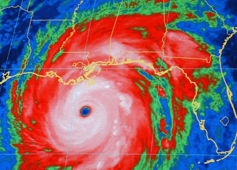
As Hurricane Season Begins, Heavy Storms Are Expected. Not sure what a “heavy storm” is – but I get the gist of this article: La Nina patterns tend to favor more numerous/extreme hurricanes (less wind shear over the tropics creates a more favorable environment for hurricanes to spin up). La Nina is weakening rapidly – expected to morph into a weak El Nino pattern later this year, so the jury is out on the implications for residents of hurricane alley. The New York Times has more: “The year began with birds falling out of the sky in Arkansas, followed by severe drought in some places and record-setting rainfall in others. This spring, a series of exceptionally destructive tornado swarms has wreaked deadly havoc across the South and Midwest, while a historic flood shoved its way down the Mississippi River. That flood is only now making its way into the Gulf of Mexico, and just in time for hurricane season. The season, which started on Wednesday and reaches its height in late summer, is forecast to be a busy one, with as many as 18 named tropical storms and three to six major hurricanes. This flurry of hurricane activity comes as part of an observable spike that started in 1995. The spike is attributable to warmer than usual ocean temperatures, though scientists are not in complete agreement on what those warmer temperatures mean, said Jeff Masters, the director of meteorology for Weather Underground, whose analyses are followed along the Gulf Coast like the sports pages. While many scientists describe this as one of the multidecade hurricane cycles that can be observed back to the 19th century, others say that the warming ocean temperatures are in fact a result of noncyclical climate change. “Is this really a cycle or not, or are we fooling ourselves?” Dr. Masters asked.”
Meteorologist On Severe Weather: “We Have Never Seen A Year Like This Before”. PBS’s Judy Woodruff interviews Dr. Jeff Masters at Weather Underground about this year’s unprecedented severe weather season. The full interview is here:
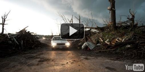
“JEFFREY BROWN: The storm in Joplin was preceded by a series of tornadoes this spring that has brought devastation to the South and Midwest. All together, it’s been the deadliest season since 1950, with more than 520 people killed so far. All of this has led to many questions about what’s behind this – what is happening this year. Judy Woodruff explores the science. Jeff Masters, let me begin with you. You have been studying meteorology for over 30 years. Just how much more severe are the storms, the tornadoes, we have been seeing this year than in the past?
JEFF MASTERS, Weather Underground: We have never seen a year like this before. It started off in mid-April, on the 14th. We had a swarm of tornadoes hit the South and then the Southeast. Over a three-day period, we had 162 tornadoes. And that was an all-time record for most tornadoes in a tornado outbreak. We have only ever seen one outbreak similar. Back in 1974, we had 148 tornadoes in one outbreak. So, that outbreak was followed just two weeks later by the most incredible outbreak we have ever seen: 362 tornadoes in a four-day span, including the Tuscaloosa-Birmingham tornado, which was probably the most damaging tornado of all time – so, more than double the previous record, which was set just two weeks before that. And on top of this, these storms dump tremendous amounts of rainfall, the heaviest rains ever recorded in April over the Ohio and Mississippi Valleys, which helped contribute to the Mississippi River floods we’re seeing.”
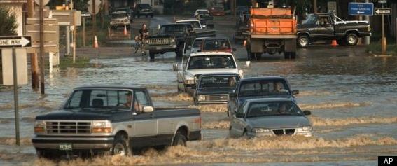
National Weather Service Predicts The Biggest Floods In Over A Decade. The problem: a record winter for snow, as much as 2 to 3 times more snow than average for the winte season. Parts of Yellowstone National Park still have 120″ of snow on the ground, the upper slopes of Aspen recently reopened for skiers – which is unprecedented. AP and Huffington Post report on the implications of a sudden thaw predicted for the next 1-2 weeks: “States across the West are bracing for major flooding in the coming weeks once a record mountain snowpack starts melting and sending water gushing into rivers, streams and low-lying communities. The catalyst will be warmer temperatures forecast for the next week that could set off a rapid thaw. Randy Julander, a supervisor with the U.S. Department of Agriculture’s Natural Resources Conservation Service, says flooding this year could be worse than anyone has ever seen. Julander said in a typical year the weather warms gradually, allowing snow in the mountains to melt slowly and ease into rivers and streams over time. That’s not the case this year after a cool, rainy spring….. The National Weather Service predicts this will be one of the top five water years in history in the Pacific Northwest, and the biggest since 1997, the last year of significant flooding, said Gina Baltrush said of the U.S. Army Corps of Engineers. Jon Lea, a hydrologist with the U.S. Natural Resources Conservation Service in Portland, said snowpack in the Western states is a combined 220 percent of average for this time of year.”
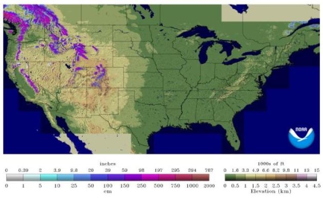
June Snowcover. According to NOAA’s National Snow Analyses (NOHRSC) there is still anywhere from 20-100″ of snow on the ground from the Sierra and Cascade range eastward to the Colorado Rockies. This map looks like something out of late March or early April, not the first week of June. Remarkable.
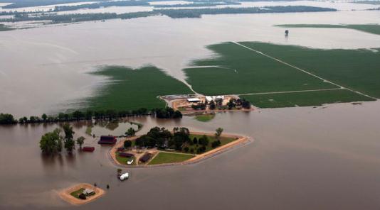
In The Wake Of Natural Disasters, Insurers Brace For Big Losses. An update from the New York Times: “Based on nearly two dozen interviews with farmers, business owners, analysts and government officials, private insurance companies are likely to experience at least $10 billion in insured losses this year, mostly associated with the tornadoes and the flooding along the Mississippi, based on property damage, lost inventory, business interruption and disrupted crop plantings. Insurance industry and risk analysis experts arrived at their projections by adding median damage estimates for the worst of the tornadoes so far. The tally will rise when private-sector insurance flood and crop claims associated with the Mississippi River flooding are tacked on and hundreds of other tornadoes and severe winter weather events are factored in. “Natural catastrophe losses in the United States are likely to be well over $10 billion by the end of 2011,” said David Smith, the senior vice president of Eqecat Inc., a catastrophe risk modeling firm. And Robert P. Hartwig, president of the Insurance Information Institute, said that just one “relatively minor” hurricane this year could push the total private insurance catastrophe losses in 2011 above the $13.6 billion paid out in 2010. Whatever the numbers prove to be, analysts acknowledge that the geographic and economic range of damage is vast. Farmland is still submerged, meaning farmers must wait until the water fully recedes to determine whether the soil is fit to replant. Damage assessment teams are still fanning out in tornado zones, surveying the destruction.”
Is New York City Way Overdue For A Hurricane? The answer is yes. The Gothamist has the story: “The devastating tornadoes in Joplin, Missouri, which were responsible for killing at least 142 people, were yet another reminder of the cruel indifference of the weather. And though it may seem like a midwest/southern problem, it really isn’t: don’t start panicking yet, but MSNBC finds that NYC is the 3rd most vulnerable and overdue city for a hurricane. And we don’t think they’re talking about appearances from Rubin Carter. Despite it being a rare occurrence in these parts, this is the second year in a row meteorologists have warned that NYC will likely face a hurricane in the near future—and will be incredibly hard to evacuate, if it came to that. According to the United States Landfalling Hurricane Probability Project, there is a greater than 90 percent probability that NYC/Long Island will be hit with a major hurricane (category 3 or more) in the next 50 years. There have only been a very few number of direct hits in the past 200 years: the 1821 Norfolk and Long Island hurricane killed 17 people, and a category one hurricane came onshore between Coney Island and JFK in 1893, causing structural damage all over (it even passed through Brooklyn). Worst of all was the New England Hurricane of 1938, a category 3 hurricane which made landfall in Suffolk County and was responsible for killing over 60 people in NY. Since then, there have been virtually no direct hits in the city by hurricanes. (Here’s a look back at Hurricane Donna’s effects on the city in the 1960s.)”
Take From http://www.startribune.com/weather/blogs/Paul_Douglas_on_Weather.html