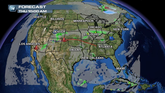
Weather Roundup: National Forecast for Oct. 9
Northeast
A back-and-forth seesaw weather pattern continues in the Northeast, with mostly decent weather in store for Thursday followed by a stalled front pushing through on Friday. Northern New England and northern portions of upstate New York will see some clouds and a spot shower for Thursday on the south side of a departing low, but Friday looks rather unsettled from southern upstate New York into southern New England as an area of low pressure pushes into the region. Saturday looks dry again, followed by another round of unsettled weather moving in Sunday night and into Monday.
(FORECAST: New York | Boston | Buffalo | Burlington)
East Central
A decent Thursday throughout the region will be followed by an area of low pressure moving into western Kentucky and Tennessee for Friday, triggering widespread showers and thunderstorms once again. By Friday night, a front will slide across from Pennsylvania all the way into Tennessee, meaning widespread storms for most of the region, but by Saturday it’ll move down into southern Virginia, North Carolina and Tennessee. It stays unsettled in Kentucky and Tennessee for Sunday.
(FORECAST: Washington D.C. | Richmond | Philadelphia | Baltimore)
(FORECAST: Nashville | Raleigh | Charlotte | Louisville)
Southeast
A few showers and storms look likely for portions of Mississippi, Alabama and Georgia – especially in the northern parts of those states – for Thursday, but by the weekend they could become a bit more widespread. A front stalls out over northern Georgia, Alabama and especially over northern and central Mississippi by Friday night, and these same areas look likely to see storms into Saturday and possibly Sunday and Monday as well. South Florida will also see their typical afternoon and evening showers and storms, but it’s otherwise looking dry for much of the region through Friday.
(FORECAST: Birmingham | Atlanta | Tampa | Miami)
South
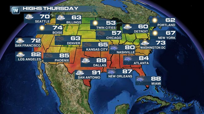
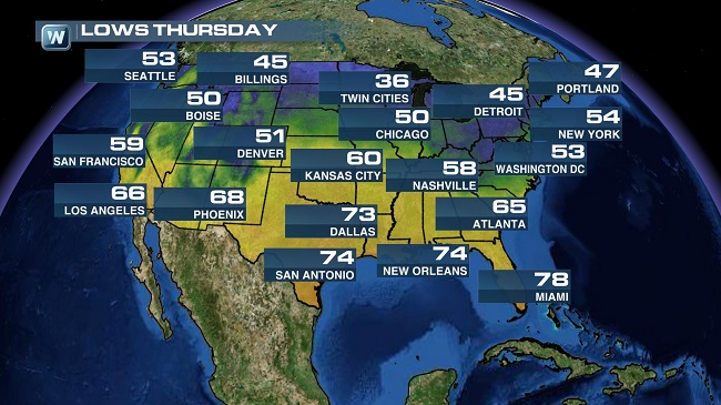
A mild morning is on tap for much of the south as lows bottom out in the upper 50s and lower 60s for the western one-fourth of the South. Other locations will bottom out in the upper 60s and low 70s. Expect another hot and sunny day across most of the South as highs top out from the mid-80s to the low 90s.
(FORECAST: Forth Worth | Austin | Little Rock | New Orleans)
Central Plains
A surface boundary and moisture from what was once Hurricane Simon will help bring scattered showers and storms to southern areas today. So while much of Missouri and Kansas can expect some rain today, areas north in Nebraska and Iowa look to remain generally dry. Morning lows will range from the 40s/50s north in Nebraska and Iowa to the 50s/60s south in Missouri and Kansas. It’ll be a cool afternoon with highs in the 60s in most spots. A few exceptions to this will be Southeast Kansas and Southwest Missouri where temperatures look to warm into the 80s.
(FORECAST: Wichita | Kansas City | Omaha | Des Moines)
Great Lakes
Upper level energy will interact with a low moving east to bring rain chances today. Showers will begin early across Illinois, spreading into Indiana and Ohio through this afternoon. Cloud cover will continue in the northern parts of the region through the day, but much of Minnesota, Wisconsin, and Michigan will stay clear and dry. Lows remain in the cool 30s in the north. Look for 40s and 50s to start the day everywhere else. High temperatures will once again be limited to the 40s, 50s, and 60s.
(FORECAST: Minneapolis | Milwaukee | Chicago | Detroit)
High Plains
Skies will remain mostly clear in the High Plains through today. A few clouds could build into southern Wyoming, bringing the potential for a few scattered showers this afternoon. Northeastern North Dakota will see chilly lows in the upper 20s and low 30s. Everywhere else will range from the mid 30s to the mid 40s. Highs will only reach the 50s and 60s.
(FORECAST: Pierre | Bismarck | Cody | Billings)
Four Corners
Tropical moisture from former Hurricane Simon will bring numerous showers and storms to New Mexico and Colorado today. Arizona will dry out after Wednesday’s rain while Utah remains nice and dry. Expect morning lows today in the 40s/50s across much of Colorado and Utah with 50s/60s south in New Mexico and Arizona. Highs this afternoon will range from the 60s in Flagstaff and Denver to the 70s in Albuquerque and Salt Lake City to the 80s in Tucson and Phoenix.
(FORECAST: Denver | Albuquerque | Phoenix | Salt Lake City)
California/Nevada
Sunny skies will continue for California and Nevada. Lows will once again be in the 30s in Northern Nevada, with 50s and 60s everywhere else. It will be a beautiful afternoon with highs in the 60s, 70s, and 80s.
(FORECAST: Las Vegas | Los Angeles | San Francisco | Reno)
Northwest
Another dry day is on tap for the Northwest today. Expect a few extra clouds for areas west of Cascades in Washington and Oregon with plenty of sunshine east into Idaho. It’ll be a cool morning with lows today in the 30s/40s generally east of the Cascades. Temperatures will start out in the 50s for most spots along I-5. Most areas will top out in the 70s this afternoon with a few 60s along the coast and over the higher elevations in Idaho. Southwest Oregon will be the warm spot once again with a high around 80 in Medford.