Typhoon Vongfong Update: Kadena Air Force Base Braces for Impact

Photo credit: NOAA
Typhoon Vongfong winds are sustained at 132-mph with gusts going up to 160-mph. The system also has a central pressure of 925 millibars. Given all this information, the Japan Meteorological Agency has classified the storm as “very strong.”
The latest update from the Joint Typhoon Warning Center has Super Typhoon Vongfong about 250 miles south-southeast of Kadena Air Force Base; moving northward at 8-mph.
Super Typhoon Vongfong is now the most powerful tropical cyclone of 2014. The storm, once equivalent of a Category 5 hurricane, has weakened, but remains a Category 4.
Potential Impacts
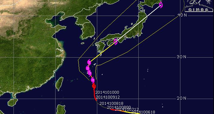
Photo credit: CIMSS
With American interests in the Pacific — most notably on the Japanese island of Okinawa — what kind of impacts are expected?
Over the last few days, the Navy’s Joint Typhoon Warning Center has moved the track of Vongfong further west. The center of the powerful Typhoon will pass within 20 miles of the Kadena Air Force Base. That means Kadena is likely to see winds sustained above hurricane-force for a number of hours. Winds above 60-mph are expected to start by 2 a.m. — local time — on Oct. 11. The worst of the storm is likely to occur between on Oct. 11, between 8 p.m. and midnight. Winds during that time could be sustained at 115-mph, with gusts in excess of 140-mph. This is a potentially dangerous and life-threatening situation, remain indoors.
Massive amounts of rain are possible on the island as well; rain in excess of a foot is not out of the question.
While it’s still the equivalent of a Category 4 hurricane, Vongfong is expected to lose some intensity as it passes Okinawa.
In a post on their Facebook page, Kadena Air Force Base officials are urging base personnel and residents to prepare for a significant hit from the powerful storm. Their threat level system, called the “Tropical Cyclone Conditions of Readiness (TCCOR),” ranges from TCCOR 4 to TCCOR 1.
The Airbase is currently on TCCOR 1 — the highest level of alertness — meaning “destructive winds are anticipated within 12 hours. ”
Here’s what the base recommends after the threat level is raised to TCCOR 1: “The storm is here! Do not go outside! This is NOT a time for cool YouTube videos. All those things that people did not fasten down in TCCOR 4 are now flying around. Wait it out. ”
After passing Okinawa, Vongfong is forecast to weaken significantly as it makes a beeline for southern Japan. Potentially making landfall near the city of Kagoshima as a Category 1-like typhoon. The storm could bring significant rain and gusty to parts of the Kagoshima Prefecture and on into the central part of the country. The Japan Meteorological Agency has issued advisories and warnings — along the southern coast — for storm surge, high waves and gales. Thus far, no “emergency warnings” — the highest level of alertness in the JMA’s warning system — has yet to be issued.
Changes to the forecast are expected and WeatherNation meteorologists will bring you the latest as it becomes available.
Vongfong’s History
Loading
Yigo Mayor and crew cut up and clear tree that's blocking village road. #guam #yigo #vongfong
Vongfong formed in the middle of the Pacific Ocean — east of Guam — early on Oct. 3 local time. Starting out as a tropical depression, the storm quickly became a tropical storm amd started its west-northwesterly track. By late on Oct. 4, Vonfong became the equivalent of a Category 1 hurricane.
As Vongfong started to close in on the U.S. Territory of Guam, the storm strengthened into a Category 2-like storm. And packing winds of 105-mph, Vongfong passed about 50 miles north of the island. Anderson Air Force Base, on Guam, recorded winds of tropical storm-force.
Another American territory — the Mariana Islands — received the brunt of the storm as it passed by. National Weather Service reporting stations on the islands recorded winds nearing 80-mph. The storm caused power outages on the island of Rota, but most customers have since been restored.
After passing Guam and the Mariana Islands, the storm underwent major strengthening — going from 105-mph to 180-mph in just 24 hours.
Comparisons to Super Typhoon Haiyan
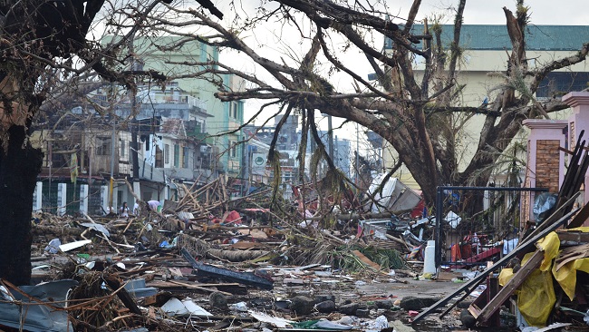
(Super Typhoon Haiyan devastated parts of the central Philippines, including the city of Tacloban. This image shows debris inundating the streets of Tacloban.)
Photo crdit: Flickr/Trocaire
There’s been quite a bit of chatter on social and digital media, comparing Vongfong to Haiyan. In Novemeber 2013 Super Typhoon Haiyan shattered global meteorology records as one of the strongest tropical cyclones ever recorded.
At it’s peak, Haiyan has sustained winds estimated at 195-mph and had a central pressure estimated to be 895 millibars. Haiyan also plowed into heavily populated areas of the central Philippines, razing whole communities and reportedly killing at least 6,000 people. Hundreds of thousands of other Filipinos we left homeless and without basic necessities.
Vongfong’s winds topped out at 180-mph and its minimum central pressure dropped to 900 millibars. By basic metrics, the storms do seem similar, but when you take into account the human costs, Haiyan casts a long shadow over Vongfong.
Meteorologist Alan Raymond