Subtropical Storm Fay Forms in the Atlantic, Other Areas of Interest Develop

It’s been a quiet this year in the Atlantic Basin, but some late season action in the tropical Atlantic is changing that a bit.
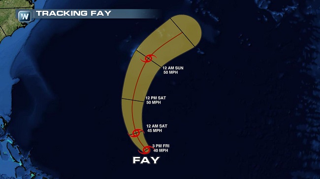
The seventh tropical depression, which has since been named Subtropical Storm Fay, developed Friday afternoon. While it’s not expected to affect the U.S., Bermuda could have some inclement weather associated with the storm as it passes the island nation on Sunday.
At present, Fay is packing winds of 40-mph and is moving north-northwest at 12-mph. Fay is expected continue on this heading through the night, before making a northerly turn on Saturday. The subtropical storm is located about 525 miles south of Bermuda and has a minimum central pressure of 1002 millibars.
The storm is expected to reach tropical storm strength later on Friday. Fay is the sixth named storm of the 2014 season.
Since the storm will come close to Bermuda, the Bermuda Weather Service has issued a tropical storm watch for the whole of the island. Tropical storm-like conditions are possible late Saturday into Sunday. In addition to the threat of winds, Fay could bring quite a dousing to Bermuda, 2 to 4 inches of rain are possible through Sunday. Large swells, especially on southern-facing shores are likely to pound beaches frequented by tourists. Rip currents will also be a large concern. So, if you have interests in the area, take the proper precautions.
Forecast models suggest only marginal strengthening is expected as Fay moves into a less favorable environment. Fay’s large size and strong vertical wind shear out of the south will inhibit any significant intensification. That said, the storm remains over very warm waters, which could perpetuate Fay’s transition to tropical system in the coming hours. That transition shouldn’t have huge impact on Fay’s overall wind field.
Other Areas of Interest
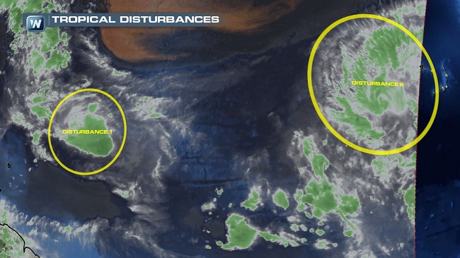
Additional tropical waves rolling off the western coast of Africa could add a bit of excitement to the tropical Atlantic, but significant development isn’t expected in the next five days.
Nevertheless, here’s what we know about the other two disturbances:
Disturbance 1: This tropical wave is located about 700 miles east of the Lesser Antilles and shows few signs of organization at this time. But in the coming days, the system will move into an area of warm sea surface temperatures and low wind shear — an environment that’s conducive to additional development. The system is moving nearly due west at 10-mph at present. It has a 10 percent chance of development in the next two days and a 30 percent chance of development in the next five days.
Disturbance 2: This collection of showers and thunderstorms is located a few hundred miles west of the Cape Verde Islands and isn’t moving into an environment that favors development. There’s a 10 percent chance of development in the next five days.
Meteorologist Alan Raymond