Record Breaking Ice And Snow Impact Northeast and Mid Atlantic
February 5th, 2014
One Million Without Power And Travel Stalled
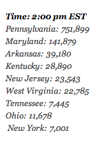
An extremely destructive weather system has been working across much of the central US, bringing with it record snow and ice. About a million customers were without power as of midday, Wednesday. Pennsylvania seeing the worst of the power outages with more than 700,000 customers affected.
Most of these outages have been caused from the thick layer of ice and snow that has fallen overnight. With difficult travel conditions and the number of outages we are seeing, power will not be restored anytime soon and may take several weeks to fully recover the grid. Here’s a rundown by state:
Storm Power Outages (Feb 5, 2013)
Total power outages: 1,034,300

Currently winter storm and ice warnings exist all the way from Missouri to Maine. Click here for WeatherNation’s interactive map for the very latest.

Above is a shot from Langhorne Pennsylvania from @seankmcginnis on Twitter. When ice freezes to trees and powerlines, it puts incredible stress from weight on them. Occasionally they give out, falling to the ground and causing damage. Please try to remain indoors and avoid walking around outside under trees or power lines in these conditions.

This is Forest Hill, MD courtesy Kelly Heil via Meteorologist Justin Berk.

Thanks to Richard Fulton for sharing the photo above from Gettysburg College in Pennsylvania.

Ice accumulations span several states and many spots are in the red or darker shades seeing as much as a half inch or more of ice. The Nation Weather Service Eastern Regional Headquarters has an interactive map to view ice and snow totals. Click Here for the latest information and individual reports.

As of right now, dry air is punching its way into the back of the storm, settling things down for most of the Ohio Valley. The worst areas currently are along the coast from Delaware to Bangor Maine. Above shows the water vapor satellite from earlier today. The darker colors indicate dry air while the bright purples and blue indicate moist air. The dry air is punching into the back side of the winter storm, causing a sharp line between precipitation and calmer conditions.

Maine, New Hampshire and Vermont are looking at snowfall rates of around 1 inch per hour. And it could come down faster in some spots. Governor Cuomo closed I-84 in northern New York due to dangerous travel conditions caused by heavy snow and freezing rain. Any car found driving on this road will be fined.
Here are are a few select daily snowfall records from Tuesday, February 4th.
Topeka,KS: 12.9″ (Previous record: 6.3″ in 1955)
Wichita,KS: 8.7″ (Previous record: 5.0″ in 1897)
Kansas City: 7.5″ (Previous record: 7.4″ in 1924)
Indianapolis: 6.8″ (Previous record: 3.6″ in 1948)
Cheyenne,WY: 5.5″ (Previous record: 4.6 in 1892)
Springfield,IL: 4.2″ (Previous record: 2.4″ in 1989)
With the recent winter storms, snow cover over the contiguous U.S. has expanded to its second highest coverage of the season at 63.6% this morning, according to NOAA. The highest percentage of snow cover this season occurred on Dec. 9, 2013 at 66.9%.


Stay tuned to WeatherNation as we track another potential storm for the weekend.