Parade of Snowstorms (coldest air retreats into Canada within 10 days)

The End is Near
To our meteorological migraine of a headache, that is – this epic cold wave, the most midwinter polar pain since 1984. For now you might want to say a silent prayer, thanking Canada for the lack of mercury in your back yard thermometer.
You’ve heard “too cold to snow”? That old, creaky proverb has some scientific merit. Of course it can snow at any temperature below 32F. But our heaviest snows pile up when temperatures are 20-30F, a storm track 200 miles southeast of MSP. Cold exhaust blowing behind a treadmill of clippers has pushed the main storm track too far south for heavy snow anytime soon. We may be brushed by flurries Tuesday; closer to 6-8 inches of flakes in Chicago.
Our weather won’t exactly be a treat: single digits & teens, probably 5 more nights below zero in the next week.
But here’s the thing: 66 extra minutes of daylight since December 21 – 2 to 3 more minutes every day. The sun is as high in the sky as it was November 6. It can’t stay this Nanook much longer. A thaw arrives next week, as this miserable Yukon vacation begins to wind down. Finally.
A well-earned spring is coming, but just this week be glad it’s not 15F warmer.
Plenty cold. Shovels optional.
* graphic above courtesy of democraticunderground.com.
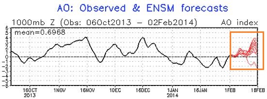
Positive Phase Of The AO. When the Arctic Oscillation is positive (stronger westerlies) North America tends to have a stronger influence from the Pacific, meaning milder temperatures overall. A negative phase means just the opposite. NOAA CPC’s latest prediction shows a fairly strong positive phase returning by mid-February. Yes, it’s going to warm up.
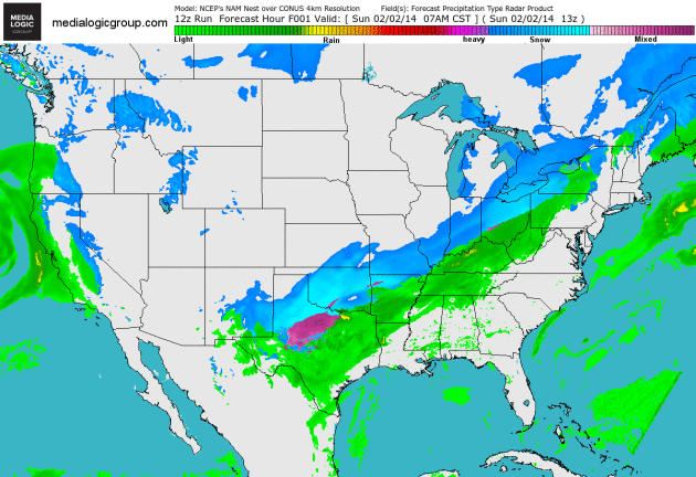
A Parade Of Southern Storms. Today’s storm spreads heavy snow across the Virginias and Maryland into Pennsylvania, brushing Baltimore and Washington D.C. with a few inches of heavy wet slush. A second, more northerly storm pushes heavy snow into Chicago and much of Michigan late Tuesday into Wednesday. NAM Future Radar courtesy of NOAA and Ham Weather.
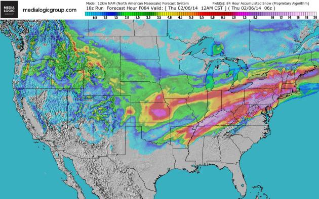
84-Hour Snowfall. Here is NOAA NAM guidance, showing the southerly streak of heavy snow today, a more northerly track of snow Tuesday and Wednesday stretching from Kansas City to Chicago, South Bend, Detroit and Cleveland to Rochester and Syracuse. Bright red implies 5″+ amounts, purple suggests 7-8″ or more. Map: Ham Weather.
Great Lakes Have Most Ice In Decades Thanks To Bitter Winter. Milwaukee’s Journal Sentinel has the story – 60% of the Great Lakes have ice cover – the most in 25 years.
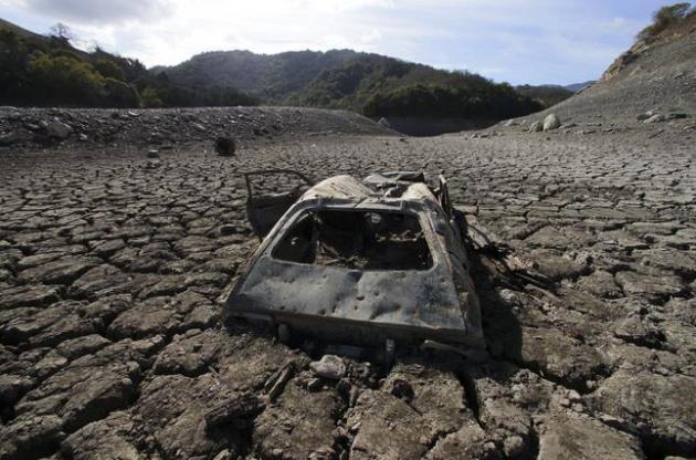
California Drought Could Force Key Water System To Cut Deliveries. Snow pack over the Sierra Nevada is 12% of normal. Stating the obvious: not good. Here’s an excerpt from The Los Angeles Times: “Officials Friday said that for the first time ever, the State Water Project that helps supply a majority of Californians may be unable to make any deliveries except to maintain public health and safety. The prospect of no deliveries from one of the state’s key water systems underscores the depth of a drought that threatens to be the worst in California’s modern history. But the practical effect is less stark because most water districts have other sources, such as local storage and groundwater, to turn to. Officials stressed that the cut did not mean faucets would run dry…”
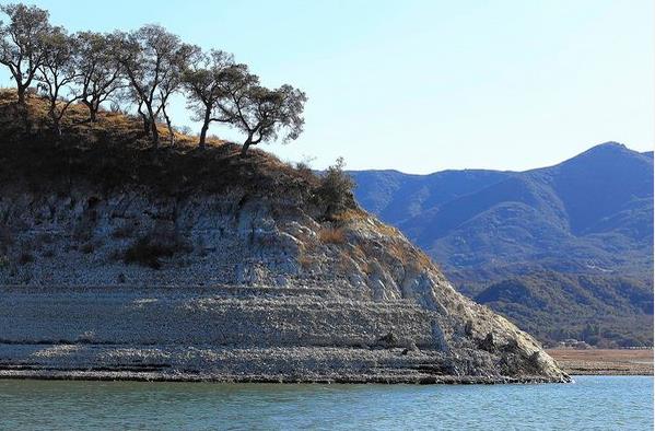
Photo credit above: “The water level in Lake Cachuma is dropping, in part because of sustained drought conditions across the state.” (Brian van der Brug, Los Angeles Times /January 14, 2014).
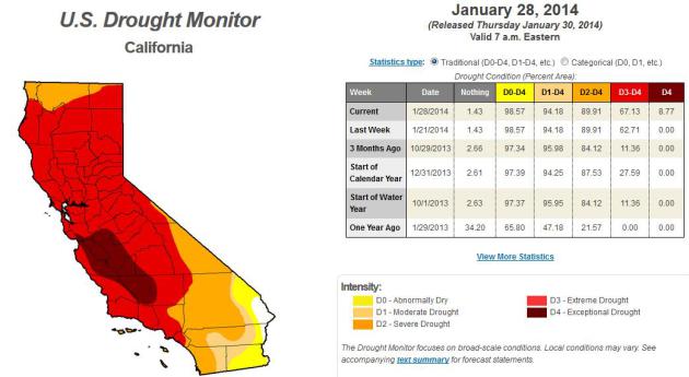
California’s Devastating Drought Isn’t Going To Get Better Any Time Soon. Slateadvances the drought narrative for California with a few statistics that made me do a double-take; here’s an excerpt: “…It’s the first time that any part of California has registered an exceptional drought in the 14-year history of the NDMC drought monitor. Now, 14 years is an admittedly short period of time. But thanks to the magic of science (and tree rings), we can now safely say that California hasn’t been this dry since around the time of Columbus, more than 500 years ago. What’s more, much of the state’s development over the last 150 years came during an abnormally wet era, which scientists say could come to a quick end with the help of human-induced climate change…”
* the latest U.S. Drought Monitor information for California is here.
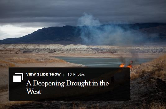
Severe Drought Has U.S. West Fearing Worst. The New York Times has the story – here’s a clip: “…This latest development has underscored the urgency of a drought that has already produced parched fields, starving livestock, and pockets of smog. “We are on track for having the worst drought in 500 years,” said B. Lynn Ingram, a professor of earth and planetary sciences at the University of California, Berkeley. Already the drought, technically in its third year, is forcing big shifts in behavior...”
Image credit above: Max Whittaker for The New York Times.
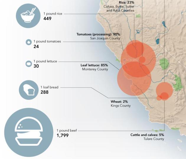
If You Like To Eat, You Should Really Be Worried About California’s Drought.Huffington Post has the story (and impressive infographic that may leave you with an urge to rush out to the grocery store to buy fresh produce); here’s a clip: “California had record low rainfall in 2013. It was potentially the driest year in the last 500 years, according totree rings, and dry weather is expected to last through 2014. The state’s $44.7 billion agriculture industry may take a significant hit, and prices for foods that are water-intensiveto produce — such as beef, milk, and tomatoes — might start reflecting California’s water woes.”
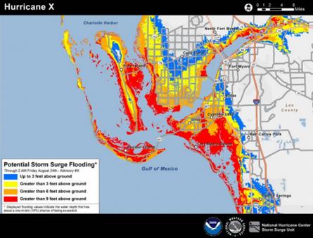
When Next Hurricane Hits, Storm Surge Will Be Mapped. Forecasting surge levels is as much an art as a science, as Sandy proved. Here’s an excerpt of a post from meteorologist Andrew Freedman at Climate Central: “The next time a hurricane hits the Gulf or Atlantic coast, the National Weather Service will be ready with a new map that it hopes will more effectively communicate the threat of deadly storm surge flooding to the public.The NWS plans to issue “potential storm surge flooding maps” together with tropical storm and hurricane watches beginning with the 2014 hurricane season, theagency announced Friday…” (Map credit: NOAA).
* more details on the upcoming hurricane storm surge forecasts from NOAA NHC.
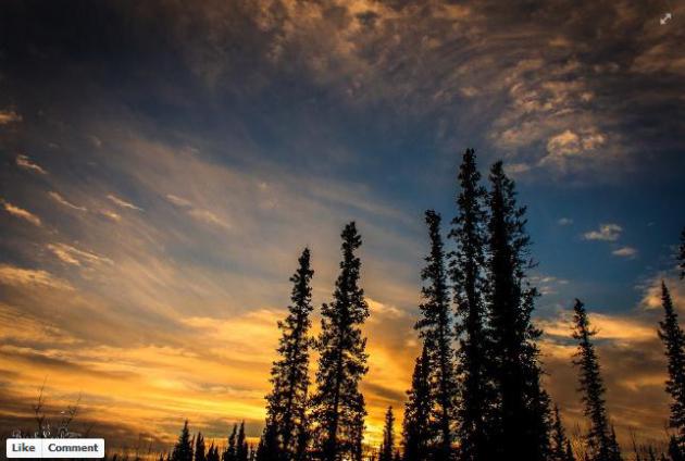
** Photo above courtesy of Birch Leaf Photography.
Climate Stories….
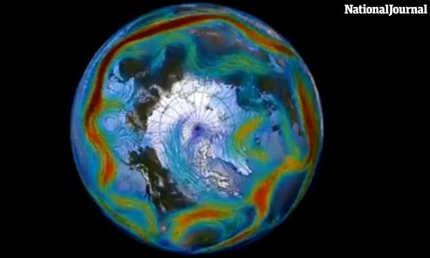
The One Video To Shut Down All of The Climate Change Deniers. NationalJournalhas the story and video; here’s an excerpt: “…Arctic air doesn’t usually travel in a loop, experts say, but in an unusual phenomenon this year, the freezing jet stream spilled southward in a spiral out of Canada. The result? Pockets of extemely cold air in places like Michigan, and unseasonably warm temperatures in states like Washington. But the media isn’t always so keen on elaborate scientific explanations or analyses of global air-flow patterns. According to Peter Sinclair, the independent videographer in charge of producing the monthly Yale video series, news networks are irresponsible in their weather coverage. “Whenever we have one of these cold snaps, we hear: ‘Oh my god! It’s cold. How can there be climate change?’ Sinclair says…”
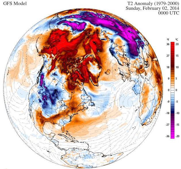
Does Polar Vortex Mean “So Much For Global Warming?” Here’s an excerpt of an Op-Ed from climate scientist Michael Mann at LiveScience: “…How can there be global warming if it’s snowing outside, after all? Well, the short answer is that cold winters still happen even in a warmed world, but that doesn’t mean it’s cold everywhere. In fact, you don’t even have to leave the United States to find a very striking image of warming. Just shift your attention from the East Coast to the West Coast. Alaska, usually snowy and frigid, has had two weeks of record high temperatures. Amazingly, the second half of January has averaged 40 F (4 C) above normal during some days in the central and western parts of the state…”
* graphic above: Climate Reanalyzer.
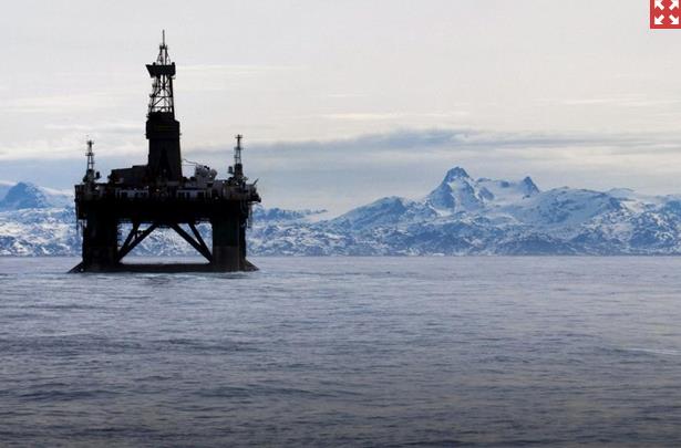
Big Oil Not Only Believes In Global Warming – They’ll Profit From It. Not my headline, but The New York Post’s headline; here’s the intro: “If this winter’s polar vortexes and accidental Atlanta ice-skating rinks have you doubting whether climate change is real, you’re not alone. In a recent Yale survey, a record 23% of Americans now deny the science. But take it from giant oil companies like ExxonMobil and Royal Dutch Shell: You’re wrong. Big Oil not only believes in global warming, it’s factoring it into the business plan…”
Photo credit above: “An oil platform off Greenland shows how far north companies are pushing with the melting of polar ice.” Photo: AP.
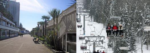
There Are Two Sochis. I thought Minnesota climate scientist Greg Laden made an important distinction in this post at scienceblogs.com; here’s an excerpt: “…Sochi is a is a resort city on the Black Sea coast with a subtropical climate, including rather mild winters. In February, the average low is 36.5 F, and the average high is 50.7 F. There will be no snow there. In fact, it may rain for part of the Olympics. Krasnaya Polyana is inland, in the Caucasus Mountains. The base elevation there, where we find the Rosa Khutor ski resort, is 1,840 feet, with higher elevations along the ski slopes reaching over 7,600 feet. Indoor events such as hockey will be held in Sochi, outdoor snow events will be held at the resort in Krasnaya Polyana. This has caused some confusion in the on-line discussion of the games...”
_____________________________________________________________________________________
ABOUT ME
Welcome to the WeatherNation blog. Every day I sift through hundreds of stories, maps, graphics and meteorological web sites, trying to capture some of the most interesting weather nuggets, the stories behind the forecast. I’ll link to stories and share some of the web sites I use. I’m still passionate about the weather, have been ever since Tropical Storm Agnes flooded my home in Lancaster, PA in 1972. I’ve started 5 weather-related companies. “EarthWatch” created the world’s first 3-D weather graphics for TV stations – Steven Spielberg used our software in “Jurassic Park” and “Twister”. My last company, “Digital Cyclone”, personalized weather for cell phones. “My-Cast” was launched in 2001 and is still going strong on iPhone, Android and Blackberry. I sold DCI to Garmin in 2007 so I could focus on my latest venture: WeatherNation. I also write a daily weather column for The Star Tribune startribune.
What’s “unusualy?”
I read the global average temp hasn’t risen in the last 15 years.