New Japanese Satellite Produces Stunning Images
A brand-new meteorological wonder is sitting 22,000 miles above the surface of the earth, snapping revolutionary images of weather phenomena worldwide.
The Japanese satellite Himawari-8, launched into orbit last October but only turning fully operational on Tuesday, is releasing incredible timelapses of typhooons traversing the Pacific Ocean.
In a statement released on Tuesday, the Japanese Meteorological Agency (JMA) said they anticipated that Himawari-8 will “open the door to a new generation of satellite meteorology, and that it will contribute to the prevention and mitigation of weather-related disasters in the East Asia and Western Pacific regions as past satellites have done.”
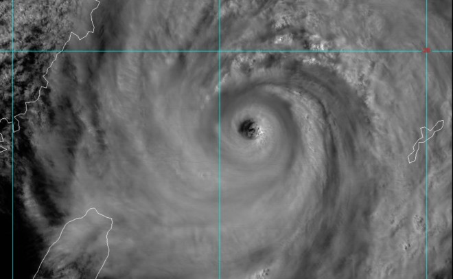
The satellite is revolutionary in that it takes three times as many photos per day as its predecessor, the Himawari-7. Snapping 144 photos per day while sitting in a stationary position above Papua New Guinea, the resolution of Himawari-8 is double that of Himawari-7. The adjacent image is one taken by the satellite of Typhoon Chan-Hom late Thursday night U.S. time as it swirled through the western Pacific Ocean.
The U.S. is planning a similar satellite of its own in March 2016, GOES-R.
Check out a collection of Himawari-8 images, courtesy of the JMA, right here!
Meteorologist Chris Bianchi – Photo: Himawari-8, via Colorado State University