Beautiful/Picturesque Supercell Thunderstorms – And What A Supercell Actually IS
We’re talking supercell thunderstorms today. What IS a supercell, you might ask? Well a simple explanation is this: a thunderstorm that has a strong updraft, and a way to evacuate cool water (rain) from the updraft – essentially making the storm self-sustaining and long-lasting. You can find a more in-depth explanation here.
A close friend of mine likes to mock me when I talk about chasing storms, saying, “You just have to find a supercell!”
This is a diagram showing what one of these storms (the classic variety) looks like:
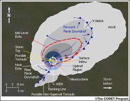
An interesting thing to note is the gray shades in the image above. The whiter shade would indicate where clouds are – but the gray shades would be precipitation as seen on radar. In a strong updraft you actually will stay dry, and rain would be miles away from the updraft – even though radar shows rain! Isn’t that interesting? I was fascinated to find that out.
There isn’t just one type of supercell, however. There are *three.*
We’re going to talk a bit more in-depth about the different types in the next few paragraphs:
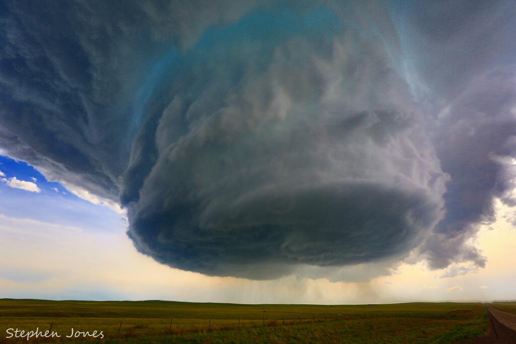
LOW PRECIPITATION SUPERCELL: Found often in the lee side of the Rockies – these tend to be the most picturesque of storms (see picture at top of blog). An LP supercell (low precipitation) will typically form in a drier climate and have less low-level moisture to work with.
They are less known for tornadoes, and if one forms it is typically a “rope” tornado. These supercells are typically known for high winds and large hail potential.
CLASSIC SUPERCELL: Found throughout the country, but generally in the Plains states, these storms are your “textbook” style of supercell thunderstorm. A strong updraft, with upper level winds that efficiently evacuate moisture from the updraft to keep it moving. These storms are known for tornadoes & hail.
HIGH PRECIPITATION SUPERCELL: Probably no surprise to hear that a type called “High Precipitation” is known for rain… but the rain causes other issues, as well. These are often seen in the South/Southeast, and are known for being overnight storms quite often as well. When they produce tornadoes, those tend to be “rain-wrapped,” meaning you can’t see the actually tornado.
These storms can produce tornadoes and gusty winds, along with hail. By far, the most frightening thing about an HP (High Precipitation) supercell is the fact that you often cannot see a tornado when it forms. They are also very difficult, and potentially dangerous, to chase.
A subset of these are what are known as “low-topped supercells.” These can have any of the characteristics of the three listed above. The only difference is that due to different temperatures/energy amounts/moisture the storms don’t rise as high in the atmosphere. They can still produce tornadoes and large hail.
Hopefully we’ll avoid having too many of these in the coming days!
WeatherNation Meteorologist Aaron Shaffer @ashafferWNTV