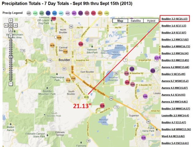
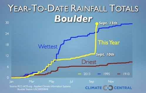
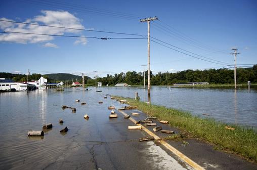
21″ Rain at South Boulder, CO. (1 in 500 year flood for parts of Front Range?)
September 17th, 2013
Hot Tea Alert
“Man plans, God laughs”.
That’s especially true when traveling by air, but I have a solution: only fly on sunny days.
Last week my flight to Baltimore was delayed 3 hours when lightning struck the control tower at BWI. Flying home yesterday I was dozing contently when clear air turbulence dumped hot tea into my crotch. Pain, then an oddly refreshing sensation.
Sorry for the visual.
My point: in spite of all our computers, gizmos & redundancies you can’t push the weather. Summer T-storms trigger more airline delays than winter snow & ice, especially over southern and eastern states. The only thing you can do to lower the risk of getting delayed or cancelled is fly in the morning, before instability T-storms have a chance to pop up and wreak havoc.

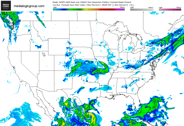
Tracking Ingrid – And A Showery Swirl Into The Midwest. The 4 km. NAM shows showers and possible T-showers sprouting along the leading edge of warmer air pushing north across the Plains into the Midwest. Colorado (finally) dries out a bit, while the soggy remains of Hurricane Ingrid push into Mexico, a few heavy rain bands brushing far southern Texas. Animation: NOAA and Ham Weather.
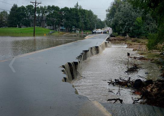
Historic Flooding Across Colorado. You only get so much from the written word, statistics and numbers. After seeing some of the photos in this piece from The Atlantic you get a much better sense of the scope of this flooding disaster: “Over the past few days, a 4,500-square-mile area across Colorado’s Front Range has been hit by devastating floods, leaving at least six dead, forcing thousands to evacuate, and destroying thousands of homes and farms. Record amounts of rainfall generated flash floods that tore up roads and lines of communication, leaving many stranded, and hundreds still listed as missing. Evacuations are still underway as weather conditions have improved slightly. Forecasters predict drier weather by mid-week. Gathered here are recent images of the devastation in Colorado.”
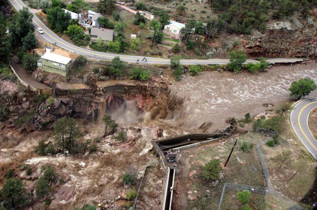
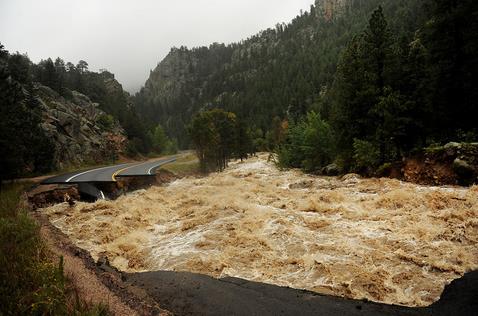
Photo credit above: “A raging waterfall destroys a bridge along Highway 34 toward Estes Park, Colorado, as flooding devastates the Front Range and thousands were forced to evacuate, on September 13, 2013.” (AP Photo/Colorado Heli-Ops, Dennis Pierce).
* In Longmont, Colorado they’re already calling this a 1 in 500 year flood.
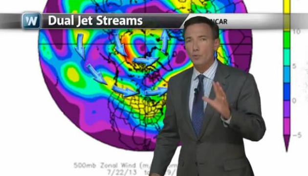
Historic Flooding Continues To Ravage Colorado. It was the Perfect Storm for the Front Range. Stalled synoptic-scale storm near Salt Lake City, turning on an extended 5-6 day “fetch” of tropical moisture originating from the eastern Pacific with record precipitable water values – combined with a stubborn upslope flow that created wave after wave of heavy rain. “Atmospheric Rivers” are thought to pose the greatest risk to California, but there’s no reason why a river of excessive moisture can’t set up from southwest to northeast, as it did late last week. Today’s Climate Matters segment looks at the Colorado Flood; natural weather enhanced by strange twists and turns in the jet stream (and more water vapor) that may be a direct result of a slowly warming climate.
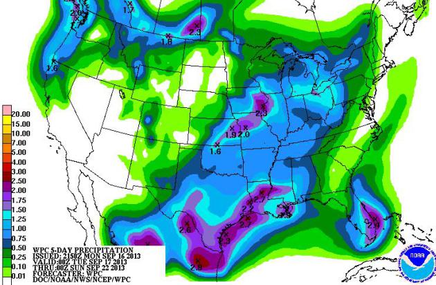
5-Day Rainfall. NOAA HPC prints out heavy rains for coastal Texas, a 1-2″+ smear of rain from near Kansas City to Davenport, more heavy showers and T-storms for south Florida. The Pacific Northwest sees a healthy soaking, while much of the Southwest stays dry.
NWS Says Flooding “Historically Significant”. No kidding. Here are more details fromThe Boulder County Business Report: “Is this week’s flooding in Boulder County a 100-year event? Five hundred? One thousand? Jim Keeney, weather program manager for the National Weather Service’s Central Region, said the NWS hasn’t made a determination because flooding is still rampant along Colorado’s Front Range. But he did offer one comparison to lend some perspective on Friday. The Big Thompson River flood of 1976 has long been a sort of benchmark for flooding in the region. That flood crested at 9.31 feet in the town of Drake. The flooding that slammed the foothills and Front Range this year crested at 10.55′ Friday morning…”
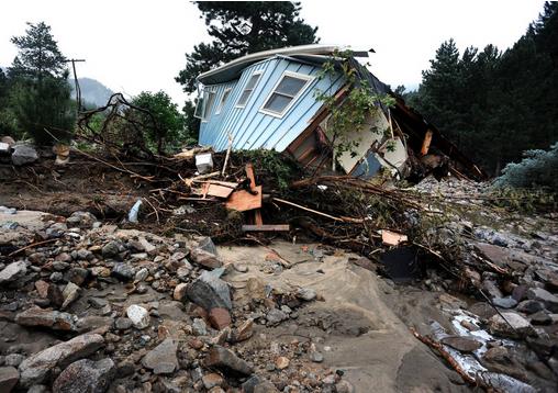
Photo credit above: “A house lays completely demolished in what was the path of the recent floods that have destroyed the town of Jamestown, Colo., on Sunday Sept. 14, 2013. No one has been able to access the town until late Sunday afternoon when crews finalized repairs of the upper portion of the road for emergency traffic only. The town has no infrastructure or running water. Some parts of town amazingly enough have electricity. A dozen or so residents stayed as most of the town was evacuated by helicopters.” (AP Photo/ The Denver Post, Helen H. Richardson)
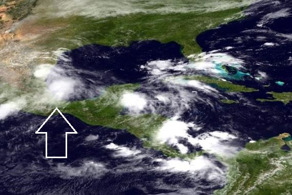
Ingrid Fizzles. Once-hurricane Ingrid should weaken rapidly today as it pushes into Mexico; some of the outer bands brushing far southern Texas (Brownsville area) with heavy rain and 30 mph wind gusts. More details from NOAA: “Monday morning (9/16/2013), the NOAA NWS National Hurricane Center indicated that Tropical Storm Ingrid continues to move farther inland from the eastern coast of Mexico, centered at midday about 25 miles west of La Pesco. A Tropical Storm Warning continues along the coast of Mexico from La Cruz northward to Rio San Fernando. Maximum sustained winds are 60 mph. Ingrid is forecast to weaken to a depression later today and dissipate on Tuesday. These rains are likely to produce life-threatening flash floods and mud slides.”
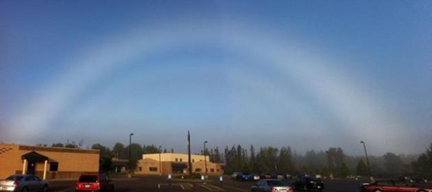
Fogbow. When it’s time to graduate from just-another-rainbow. Details fromWeatherNation TV: “Here’s a cool weather phenomenon! This photo was taken in Cloquet, MN. Fog bows are similar to rainbows, except due to a smaller droplet size, white is the color reflected to the eye instead of the normal ROYGBIV. Photo from Jason Hollinday via NWS Duluth, MN.”


The iPhone’s Secret Flights From China To Your Local Apple Store. Apple flies chartered 777’s from China, each one loaded with 400,000+ iPhones. Who knew? Here’s an excerpt of a fascinating tale from Bloomberg: “As Apple CEO Tim Cook unveiled new iPhones yesterday, a complex operation had already kicked into gear behind the scenes to send millions of the handsets to store shelves worldwide. The process starts in China, where pallets of iPhones are moved from factories in unmarked containers accompanied by a security detail. The containers are then loaded onto trucks and shipped via pre-bought airfreight space, including on old Russian military transports. The journey ends in stores where the world’s biggest technology company makes constant adjustments based on demand, said people who have worked on Apple’s logistics and asked not to be identified because the process is secret…”
Photo credit above: Simon Dawson/Bloomberg. “Boxes of Apple Inc. iPhones are stacked in a London store.”


Climate Stories…
Why Did Colorado See Historic Flooding? Natural weather patterns, turbocharged by an unusual jet stream feature that caused a storm to stall for the better part of 5-6 days + record amounts of tropical moisture flowing from the eastern Pacific across Mexico into Colorado. Did climate change make the floods worse? Probably. Here’s a clip from Peter Sinclair at Climate Denial Crock Of The Week: “…A blocking pattern has set up over the western United States, drawing a conveyor belt of tropical moisture north from coastal Mexico. Blocking patterns form when the jet stream slows to a crawl, and weather patterns get stuck in place. When all that warm, wet air hit the Rocky Mountains, it had nowhere to go but up, pushed further skyward by the mountains themselves. By some measurements, the atmosphere at the time of the heaviest rains was the among most soaked it has ever been in Colorado. Gauge measurements show floodwaters in Colorado have now exceeded the legendary Big Thompson Canyon Flood of 1976, the flood of record for the region. In downtown Boulder, a meandering creek expanded 40-fold in just a few hours…”
Photo credit above: occuworld.org.

Environmental Consequences Of Fracking. If you’re interested in learning more about fracking and the impact on the environment I encourage you to attend this evening’s meeting of the Minnehaha Chapter of the Izaak Walton League at 7 PM this evening. The presenter is Matt Norton, Campaign Director at the Minnesota Environmental Partnership (MEP). The location: Linden Hills Recreation Center, 3100 West 43rd Street, Minneapolis, Minnesota 55408.

Encouraging Results Seen In First Nationwide Look At Gas Leaks From Drilling Boom. There are still many unanswered questions about the long-term environmental safety of hydraulic fracture, or “fracking”, including possible negative impacts on groundwater and a potential link between injecting water and chemicals deep underground, as well as a rash of recent (small) earth tremors near drilling sites. But recent papers suggest methane leakage from fracking may not be as bad as previously thought. The jury is still out, but the process is still considerably cleaner than coal. Here’s an excerpt of an Andrew Revkin post at The New York Time’s Dot Earth: “…The analysis, led by David T. Allen and other energy and environment researchers at the University of Texas, finds that estimates of methane escaping from gas drilling made by the Environmental Protection Agency are fairly accurate, over all, while those from industry critics and some indirect studies of leakage (from aerial measurements, for example) appear far too high. A comprehensive package of background on the research has been posted by the university. While the researchers found that emissions from a critical stage of well construction — “completions” — are far lower than regulators had estimated, they pinpointed an important under-appreciated source of escaping gas — pneumatic devices powered by the pressure of the extracted natural gas…”
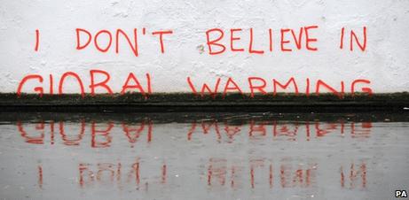
The 5 Stages Of Climate Denial Are On Display Ahead Of The IPCC Report. The Guardian has the story – here’s a clip: “…Just in the past week we’ve seen:
- The David Rose Mail on Sunday piece that treated scientific evidence in much the way bakers treat pretzel dough.
- Dr. John Christy interviewed by the Daily Mail;
- Christy’s colleague Dr. Roy Spencer in The Christian Post;
- Andrew Montford in Rupert Murdoch’s The Australian;
- Matt Ridley in Rupert Murdoch’s Wall Street Journal; and
- Bjorn Lomborg in The Washington Post.
Interestingly, these pieces spanned nearly the full spectrum of the 5 stages of global warming denial.
Stage 1: Deny the Problem Exists
Often when people are first faced with an inconvenient problem, the immediate reaction involves denying its existence. For a long time climate contrarians denied that the planet was warming. Usually this involves disputing the accuracy of the surface temperature record, given that the data clearly indicate rapid warming…”
_______________________________________________________________
ABOUT ME

Welcome to the WeatherNation blog. Every day I sift through hundreds of stories, maps, graphics and meteorological web sites, trying to capture some of the most interesting weather nuggets, the stories behind the forecast. I’ll link to stories and share some of the web sites I use. I’m still passionate about the weather, have been ever since Tropical Storm Agnes flooded my home in Lancaster, PA in 1972. I’ve started 5 weather-related companies. “EarthWatch” created the world’s first 3-D weather graphics for TV stations – Steven Spielberg used our software in “Jurassic Park” and “Twister”. My last company, “Digital Cyclone”, personalized weather for cell phones. “My-Cast” was launched in 2001 and is still going strong on iPhone, Android and Blackberry. I sold DCI to Garmin in 2007 so I could focus on my latest venture: WeatherNation. I also write a daily weather column for The Star Tribune startribune.